
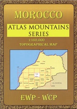
Hiking map Toubkal Massif Morocco 1:160,000
- Regular Price
- €17,95
- Sale Price
- €17,95
- Regular Price
- Unit Price
- per
Deliver in 1-5 days
| ISBN-EAN | 9780906227985 |
| Uitgever | EWP |
| Bindwijze | Paperback |
| Taal | English French |
| Levertijd | 1-5 days |
| Soort | Walking maps |
This map is part of several detailed topographical maps of the Atlas Mountains and the adjacent deserts. Each card has local tourist info on the back.
Elevation in contour lines with 40m intervals and a number of points. Further mention of terrain type, vegetation, water points, cliffs, dunes, ravines, salt pans, etc. For roads, a distinction is made between unpaved, paved and tracks. Buildings, airports, stations, electrical lines. For some passes there is an indication when it is passable.
The publisher EWP reports these maps are suitable for the use of GPS. (the main grid drawn over the mapping is based on the Kronstadt system which related closely to the UTM system, and which th epublishers assure us is suitable for a GPS set to UTM or MGRS.)
Full color topographical map covering the Taroudant, Tafraoute and neighboring regions of the Anti-Atlas.
Tourist information covering access, main features, trails and glossary. Text in French and English. Inset overview map.